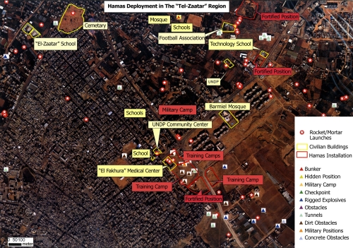
The lady in the video above may think its funny...but below is a map provided by the IDF outlines which rocket launchers were using which schools, hospitals, mosques, etc. and the people who frequent them, as human shields:
IDF Maps Reveal Hamas Exploitation of Gazan Residents
Hamas exploits the civilians of the Gaza strip as human shields. Here are two aerial photographs which illustrate how Hamas deploys rocket launchers within densely populated areas in the Gaza strip, next to schools, mosques and medical facilities. Residential buildings are used as arms depots and rigged with explosive charges, without any consideration given to potential civilian casualties.
- White stars in red circles - rocket/mortar launchers
- Yellow lines - civilian buildings
- Red lines - hamas installations
- Red triangles - bunkers
- Yellow triangles - hidden positions
- Blue triangles - rigged explosives
- Grey triangles -tunnels
- Purple triangles - obstacles


No comments:
Post a Comment